Our final prezi presentation for Haifa.
Overall we were very happy with the work we produced. As a group i think we all worked well together and produced a high standard of work.
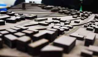
Our final laser cut model of Haifa. This although looks fairly simple is actually quite complex because of the topography of the site which we had to take into consideration. This was difficult to laser cut as we needed cuts outs on certain layers where buildings were sitting in the side of the hill.
Saturday, 27 April 2013
Friday, 19 April 2013
WEEK 07
This week was project week, with no lecture we looked at finishing the scale model off and finalising our drawings for the final presentation. The model was finished and we decided to focus our attention onto the report. We looked over lectures and tried to apply the theories to our city and incorporate this into the report.
The street section of the main street in Haifa shows the planned formation and linear forms of the street which is a direct contrast to the other streets in Haifa which are very organic and are influenced by the surrounding Mt Carmel.
The street section of the main street in Haifa shows the planned formation and linear forms of the street which is a direct contrast to the other streets in Haifa which are very organic and are influenced by the surrounding Mt Carmel.
Thursday, 11 April 2013
WEEK 06
In this lecture we looked at some examples of work produced by students which set the standard of work that we were to be expected to produce. The lecture was about "Around the world in 8 cities", Mirko looked at the relationships of typologies of different cities that informed those who occupy it. It was interesting in understanding the types of planning in the cities which made me start thinking about the relevance this had to our city, Haifa.
Highlighted in the figure ground map is the axis line which runs from the Shrine of the Bab down toward the port. This is the only straight or planned development in the town. Haifa is a very religious town with the population booming after the 1900's when a railway joined Haifa to the north and allowed for trade and transport to arrive from Egypt and the north. In the figureground I have decided to highlight the mountains in grey as they are a key factor in the design of the city.
The forma urbis shows the town as a very organic form. The large mountains (Mt Carmel) prevent any further development upwards. The main highway is highlighted which connects Haifa with the northern town called Acre.
The graph shows a mass increase in population around the 19th century which was when the German templars ruled Haifa. They linked the city by railway with Damascus and Egypt. Population grew from 4,000 to 150,000.
Old Haifa- 37BCE to 640AD
Haifa Middle Ages- 640 to 1291AD
Modern Haifa- 1761 to 1918
In 1868 the German colony arrived- first planned farming village and largest most important in Israel at the time. 30meter wide tree lined avenue on north-south axis. (Ben Gurion St)
Haifa the British Mandate period- 1918 to 1948
Some sketches of some key buildings in the area which are of significance. Buildings 1-5 are all religious buildings of the Bahai faith and are found in the gardens.
The buildings are highlighted on the map. There was no hidden spaces (eg. plaza's etc) that could be highlighted in the nolli map. All of the buildings apart from the ones highlighted were off similar build, all domestic with commercial use underneath.
Building the model of the city was very hard due to the steep gradient of the topography. Having the buildings cut into the hill and lining up each layer was crucial. This week we analyses Haifa's urban morphology. By using street view and google earth we were able to make accurate estimates of the heights of the buildings and used this to generate our map.
The information we used to generate the historical map was gathered from a wide range of online journals and books from the library which we used to estimate the urban sprawl.
ASSIGNMENT:
The forma urbis shows the town as a very organic form. The large mountains (Mt Carmel) prevent any further development upwards. The main highway is highlighted which connects Haifa with the northern town called Acre.
Old Haifa- 37BCE to 640AD
Haifa Middle Ages- 640 to 1291AD
Modern Haifa- 1761 to 1918
In 1868 the German colony arrived- first planned farming village and largest most important in Israel at the time. 30meter wide tree lined avenue on north-south axis. (Ben Gurion St)
Haifa the British Mandate period- 1918 to 1948
Some sketches of some key buildings in the area which are of significance. Buildings 1-5 are all religious buildings of the Bahai faith and are found in the gardens.
The buildings are highlighted on the map. There was no hidden spaces (eg. plaza's etc) that could be highlighted in the nolli map. All of the buildings apart from the ones highlighted were off similar build, all domestic with commercial use underneath.
Building the model of the city was very hard due to the steep gradient of the topography. Having the buildings cut into the hill and lining up each layer was crucial. This week we analyses Haifa's urban morphology. By using street view and google earth we were able to make accurate estimates of the heights of the buildings and used this to generate our map.
The information we used to generate the historical map was gathered from a wide range of online journals and books from the library which we used to estimate the urban sprawl.
Subscribe to:
Comments (Atom)


